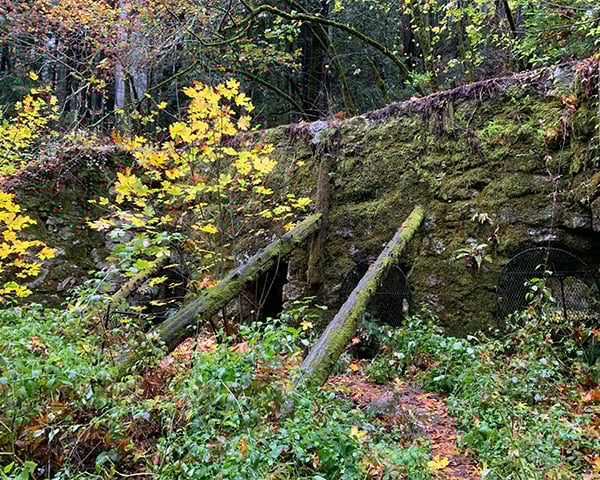
Located in Davenport, where the Pacific Ocean meets rolling coastal grasslands, lies a place with stories as deep as its redwood roots: Cotoni-Coast Dairies (pronounced Chuh-toe-knee). Part of the 5,800-acre on-shore unit of the California Coastal National Monument, Cotoni-Coast Dairies is both a wild refuge and living history.
The land carries the name of the Cotoni, the indigenous people who called these hills and meadows home long before Europeans arrived. The Bureau of Land Management now cares for this place, and it’s clear they have worked hard to preserve the heritage of all those who have called this land home – human and animal alike. Here, perennial streams wind down from the redwood-forested Santa Cruz Mountains, weaving through shady oak woodlands and sunlit prairie before spilling into the ocean. The Cotoni Coast’s diverse topography makes for a biologically rich mosaic of ecosystems. Redwoods stretch skyward, hawks soar overhead, and freshwater streams sustain fish and flow onward to nourish the city of Santa Cruz and its neighbors. For visitors, hikers, bikers, and nature lovers alike, Cotoni-Coast Dairies offers an opportunity to experience the wild beauty of the California Central Coast.

Trails
With over 8 miles of trails lovingly built by Santa Cruz Mountains Trail Stewardship, a local non-profit, the Cotoni Coast-Dairies are waiting to be discovered! One trailhead leads from the parking lot to all other paths, which are organized as a stack of loops, each feeding into the next. This means that to get to the most challenging trail, you’ll need to traverse the two other trails, both on your way in and on your way out. Whether you’re hiking, biking, or riding horseback (permit required), each path offers its own distinctive encounter with the land. Two of the pathways are dog-friendly, just be sure to keep your furry friends on leash!
A hot tip: when hitting the trails, be prepared to encounter poison oak along the way.
Easy – Hawk / Káknu (2.5 mile loop)
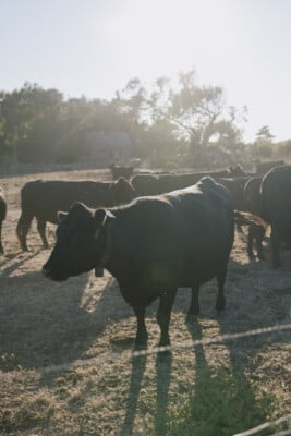
The first path you’ll encounter is the Hawk Trail—in Cotoni, Káknu (pronounced KAHK-noo). This 2.5-mile beginner-friendly loop meanders through the coastal prairie, where cattle graze in tall, swaying grasses and the ocean shimmers endlessly on the horizon. Beneath the sweep of a vast sky, it’s easy to understand why the hawk takes to the air. With its wide tread, the trail is certified for adaptive mountain biking and welcomes hikers and on-leash dogs alike.
Moderate – Tree / Huyya (1.6 mile loop)
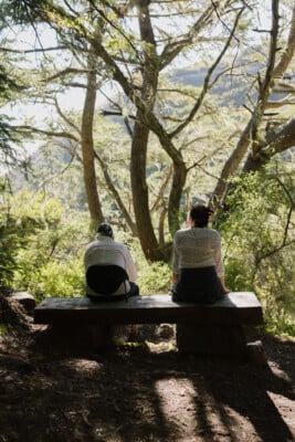
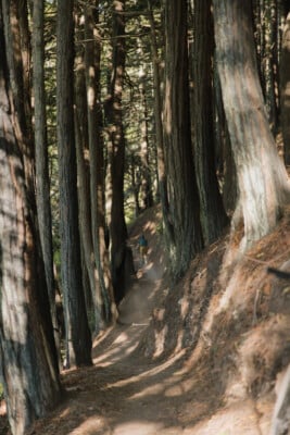
The next loop along the way weaves into a forest, the path narrowing as you become dwarfed by the majestic redwoods towering above. Appropriately named the Tree Trail, Huyya (HOO-yah) in Cotoni, this 1.6-mile moderate trail made for hiking and biking provides relief from the elements and cooling shade under the cover of the ancient trees. It’s on-leash dog-friendly, too! As you make your way through the woods, a quiet bench offers a perfect pause to glimpse the ocean framed by the forest canopy.
Challenging: Wildcat / Toróma (4 mile loop)
Those seeking a challenge should head out to the Wildcat Trail – Toróma (toh-ROH-mah) in Cotoni- which stretches 4 miles and reaches the highest points in the park. The ascent rewards with panoramic views, but it’s a journey that demands preparation: bring ample water, snacks, and time. The moderate/difficult-rated trail was created for hikers and bikers only, so please leave your four-legged friends on the other trails. At the summit of the plateau, the view rivals the unforgettable memories formed along the way.
Know Before You Go
Cotoni-Coast Dairies is open seven days a week, sunrise to sunset. You’ll find the trailhead at:
1 Cement Plant Rd, Davenport, CA 95017
- Parking: 62 spaces available
- Restrooms: Located near the trailhead
- Water: There is none on-site – bring your own, and plenty of it!
- Essentials: Sunscreen, snacks, and good shoes
- Wildlife: Cattle graze across the property – share the space with respect to the animals!
- Be prepared and download trail maps ahead of time!
To explore the trails of Cotoni-Coast Dairies is to move through layered histories: those of the Cotoni people, of the forest and sea, and of today’s stewards working to keep these lands open for all. Thanks to the dedicated efforts of the Bureau of Land Management and Santa Cruz Mountains Trail Stewardship in restoring and building these trails, they are now accessible for the public to enjoy every day of the week. Here, every step tells a story, and every visit becomes part of the ongoing legacy of this incredible landscape.