


Below are a few history-rich hikes in the Santa Cruz Mountains with stories to tell about loggers and environmentalists and other California dreamers who were drawn to these mountains, just as we are today. There are hikes in Big Basin that we can look forward to taking one day, and hikes in Nisene Marks and Fall Creek that are open and available now.
Scientists tell us that before 1800, about 4.5 million acres burned each year in California. Fire — both controlled burns set by indigenous people as a land management technique and wildfires that raced out of control — have shaped the state’s landscape for millennia. Many plants have evolved to release their seeds only when their pods are superheated, as happens in a wildfire. Redwood trees have tough fire-resistant outer bark that enables them to survive infernos that would incinerate other trees.
The CZU wildfire of August 2020 burned more than 85,000 acres in Santa Cruz and San Mateo counties, including a large percentage of Big Basin Redwoods State Park and parts of the Fall Creek Unit of Henry Cowell Redwoods State Park (as of May 2022, all trails at Fall Creek are open). Big Basin is closed until further notice, and parks lovers everywhere are feeling the loss. But these ecosystems evolved to survive wildfire. They’ll regenerate. They will come back healthier than we’ve ever seen them in our lifetimes. This is part of the cycle of life in the Golden State, a place bursting with natural beauty. It’s history in the making, and we will get to witness the regeneration of these forests.
Read on to plan your next historical hike in the Santa Cruz Mountains. Learn more about the resilience of redwood trees and the survival of Big Basin’s beloved Mother and Father of the Forest in Redwood Love.
Lime Kilns and Barrel Mill at Fall Creek
Henry Cowell Redwoods State Park, Fall Creek Unit
5.5 miles RT
Just west of the mountain town of Felton lies the Fall Creek Unit of Henry Cowell Redwoods State Park. Quieter than the main portion of the park, which has a campground, visitor center and a magnificent stand of old-growth redwood trees, Fall Creek consists of 20 miles of trail, very few old-growth redwoods, and no facilities—but its intriguing historical features are still intact and its trails pleasantly uncrowded.
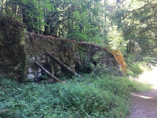
In 1875 the IXL Lime Company of San Francisco purchased this tract to produce lime for the mortar used in masonry buildings. California’s population was booming, and a series of dramatic fires had caused wooden structures to fall out of favor. The pressing need for mortar—and the redwood trees of the Fall Creek watershed—fueled three kilns that ran 24/7 from 1875 to 1896 and produced 50,000 barrels of lime per year. Santa Cruz County’s lime production accounted for a third of California’s supply and three-quarters of San Francisco’s, but the business came at a cost: each of the three kilns burned for three to four days, requiring 70 cords of wood—redwood—to produce 1,000 barrels of lime. The watershed was logged almost bare to fire the kilns and make the barrels.
In 1900, lime magnate Henry Cowell purchased the lime works and supplied much of San Francisco’s need following the 1906 earthquake, but lime was soon displaced by cement, and the kilns closed in 1919.
Today the kilns are overgrown with moss, weeds and even trees, but they retain a sort of grandeur. To get there, take the Bennett Creek Trail from the parking lot on Felton Empire Road, then follow Fall Creek Trail for about ¾ of a mile along a redwood-shaded path next to the creek. Cross the footbridge and stay to the left, continuing along the South Fork of Fall Creek until you get to the lime kilns. Look for the Blue Cliff a few hundred feet beyond the kilns; it’s the source of the limestone.
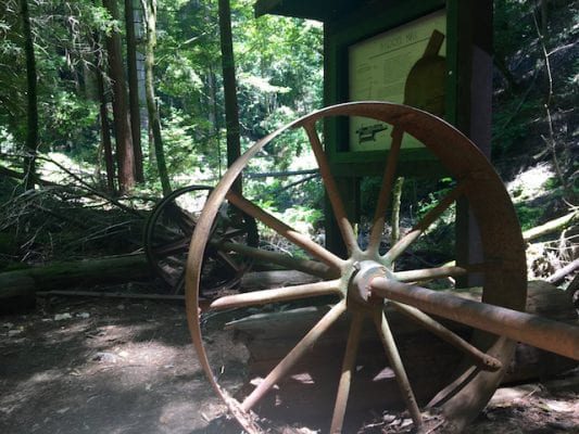
To visit the barrel mill site built by Henry Cowell’s son Samuel in 1912, follow the Cape Horn Trail at the Powder Magazine, just a few hundred feet from the lime kilns, and take it to the Fall Creek Trail, then proceed to the barrel mill site. This trail is not for the faint of heart; it requires scrambling over and under logs and crossing Fall Creek via a jumble of rocks and logs.
Return the way you came, unless you feel like taking a really big hike. In that case, continue on Fall Creek Trail to the Big Ben Trail and turn left to make your way to the park’s lone old growth redwood. Follow the signs back to the parking lot via Lost Empire Trail (total mileage: 8+).
Note: Do not rely on the map on your phone here; many people get lost doing that. Instead, go to the main unit of Henry Cowell Redwoods State Park to pay the $10 entrance fee and receive a complimentary paper map.
The Fall Creek Unit parking lot is ¾ of a mile west of Highway 9 on Felton Empire Road.
Slippery Rock and Sempervirens Falls via Sequoia Trail (temporarily closed)
4 miles RT
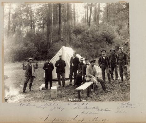
On May 18, 1900, a party of writers, scientists, artists and citizens concerned about the rampant logging of redwoods in the Santa Cruz Mountains camped between a waterfall and the base of a peculiar sloping rock formation at the edge of the forest. That night they formed a plan. They would call themselves the Sempervirens Club and dedicate themselves to saving the mighty redwood trees from the saw. They passed a hat to fund their fledgling operation: the take was $32.
Within two years the men and women of the Sempervirens Club had succeeded in saving 3800 acres, including a magnificent old-growth grove, and persuading the California legislature to purchase the tract as California’s first state park. The establishment of California Redwood Park, now known as Big Basin Redwoods State Park, didn’t just launch the state park system, it gave birth to the modern conservation movement in California. And it all started with a camping trip.
The Sequoia Trail, which makes a loop starting at park headquarters, leads past the picturesque Sempervirens Falls, which remains much as it was in 1900, and up the Slippery Rock, an outcropping of Miocene sandstone (careful in wet weather!). You’ll notice the historical marker for the Sempervirens Club campsite between the two landmarks.
The Sequoia Trail itself is one of the oldest in the park, possibly used as early as 1875. The section between Opal Creek and Slippery Rock, once known as the Trail Beautiful, was built in 1895. Part of this section, which comes right up to Highway 236, dips down into a really gorgeous ravine with some spectacular old-growth specimens on its way down to Opal Creek. Note the cloudy turquoise-and-amber waters of this creek, its color due to tannins in the water from the redwoods.
If you haven’t already, you can walk the half-mile Redwood Trail with its enormous old-growth trees for a vivid illustration of what the Sempervirens Club accomplished.
Big Basin Redwoods State Park, 21600 Big Basin Way, Boulder Creek. 831.338.8860. $10 vehicle use fee.
Hoffman’s Historic Site via Loma Prieta Grade Trail
Forest of Nisene Marks State Park
4 miles RT from Porter Picnic Area (with option to extend to Maple Falls for a 7.7-mile RT). Please note that Porter Picnic Area is closed in winter.
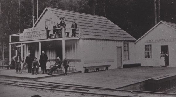
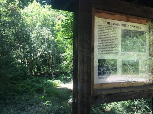
Though logging in Santa Cruz County officially started booming with the Gold Rush, nobody even considered trying to log steep, narrow Aptos Canyon until the early 1880s, when the mighty Southern Pacific Railroad Corporation stepped in to fund the Loma Prieta Logging Company. By 1890 Chinese laborers had laid 7.5 miles of standard gauge track alongside Aptos Creek so trains could pull huge redwood logs from the depths of the canyon to the mill and on to market. At one point the Loma Prieta Sawmill was cutting 70,000 board feet of virgin redwood a day, and the town of Loma Prieta was home to 300 citizens, a hotel, a saloon, a Wells Fargo office and a school district.
Once the trees were gone, the town and the sawmill shut down, and eventually the tracks were pulled up to create what is now Aptos Creek Fire Road, the main arterial through a beautiful second-growth redwood forest and the largest state park in the county.
This hike to the site of an old logging camp that operated from 1918 to 1921 starts at the Porter Family Picnic Area (closed in winter, but you can park at George’s Picnic Area year-round and walk the mile to Porter’s). A quarter mile from Porter’s, Loma Prieta Grade Trail leads off to the left up a gentle incline. The trail follows a narrow-gauge railroad built by the Loma Prieta Lumber Company for its last foray into the watershed, to a place called Big Tree Gulch famed for the 15- to 18-foot diameter redwoods that grew there. (It’s now called Big Stump Gulch.) Reportedly the best-preserved narrow gauge railbed in the county, the trail hugs the side of the Bridge Creek canyon as it climbs ever upward. One dizzying stretch features an 80-foot dropoff to the creek below. Railroad ties are visible occasionally along the entire route.
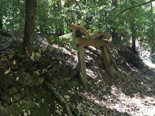
Note the A-frame structure about halfway to Hoffman’s Historic Site; it once supported a water tank for the locomotives. Keep an eye out for a stand of eucalyptus where the logging company had a reforestation experiment until officials realized that eucalyptus, though fast-growing, makes poor lumber.
Little remains of Hoffman’s Historic Site, which once had a 120-foot-long bunkhouse and a dozen buildings, but it’s a nice place for a snack. Turn around and go back the way you came, or else continue on through Big Stump Gulch to the Bridge Creek Trail and turn left to get to 30-foot Maple Falls (slippery going in winter). Return via Bridge Creek Trail, which rejoins Loma Prieta Grade Trail.
Whether you go to Maple Falls or not, take the short Mill Pond Trail cutoff on your return (left at the Porter House Site) to see the old Loma Prieta town and mill sites.
Forest of Nisene Marks State Park, Aptos Creek Road, off Soquel and State Park Drive, Aptos. 831.763.7062. Entrance fee: $8.
Interested in more hikes? Explore these Lime Kiln Hikes for more historical exploration or the Santa Cruz County’s Top 5 Hikes that highlight the diversity of landscapes in the area.